
In a world driven by digital maps, GPS services, and on-demand deliveries, India's traditional 6-digit PIN code is no longer sufficient. It was designed in 1972 to simplify postal delivery by identifying large geographical regions. However, the same PIN code covers multiple post offices and a vast area, making it inefficient for modern needs like doorstep deliveries, precise emergency response, and detailed urban planning.
Enter DIGIPIN — a revolutionary geo-coded digital address system launched by India Post in collaboration with IIT Hyderabad. Unlike PIN codes, which are area-based, DIGIPIN is location-specific and GPS-friendly.
DIGIPIN is a 10-character alphanumeric code that represents a specific 4x4 meter area anywhere in India. It bridges the physical and digital worlds by converting geographic coordinates (latitude and longitude) into a human-readable, logical code.
- Geographic Location Encoding: DIGIPIN contains the geographic location of the area. It is possible to extract the latitude and longitude of the address from the DIGIPIN with low complexity.
- India-Specific Design: DIGIPIN has been designed for the Indian context. All points of interest to India (including maritime regions) can be assigned codes, and it is possible to assign unique digital addresses even in areas that are very densely populated.
- Intuitive Format: The format of the DIGIPIN is intuitive and human-readable. Effort was made to infuse a sense of directionality within the format of DIGIPIN.
- Infrastructure Independence: DIGIPIN is independent of the land use pattern and the structure built. DIGIPIN is designed as a permanent digital infrastructure, that does not change with changes in the names of state, city or locality, or with changes in the road network in an area.
- Future-Proof Design: The DIGIPIN is designed to be robust to accommodate future developments and changes. The arrival of a new building in a community, or even a new village or city in a district, or changes in the name of a road or locality will not affect the underlying DIGIPIN.
- Efficient Length: The length of the DIGIPIN is designed to be as small as possible in order to provide an efficient digital representation of addresses.
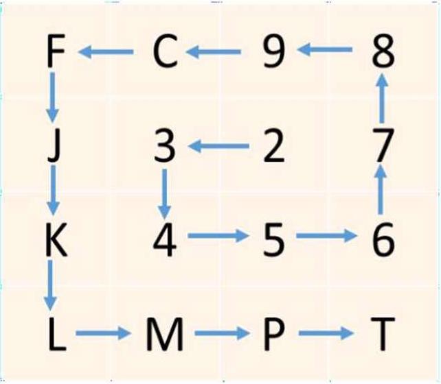
The Detailed structure is such that the DIGIPIN is essentially an encoding of the latitude and longitude of the address into a sequence of alphanumeric symbols using the following 16 symbols:
2, 3, 4, 5, 6, 7, 8, 9, C, F, J, K, L, M, P, T
Hierarchical Encoding Process:
- 1. Bounding Box: A bounding box is used that covers the entire country.
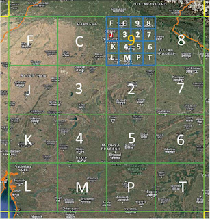
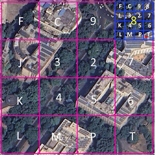
- 2. Level-1 Partition: The bounding box is split into 16 (i.e., 4x4) regions. Each region is labeled by one of the 16 symbols. The first character in the code identifies one of these regions.
- 3. Level-2 Partition: Each region is then subdivided into 16 subregions in a similar fashion. The second character identifies the subregion, creating 162 = 256 subregions.
- 4. Successive Levels: The encoding continues for 8 more levels in an identical fashion. The 10-symbol code uniquely identifies one of the 1610 cells within the bounding box.
Grid labeling pattern showing anticlockwise spiral direction for levels 2-10
Bounding Box Specifications:
- Longitude: 63.5° – 99.5° East
- Latitude: 2.5° – 38.5° North
- Coordinate Reference System (CRS): EPSG:4326 (WGS84)
Bounding Box Design Considerations:
- • Includes the entire territory of India.
- • Includes the maritime Exclusive Economic Zone (EEZ) - 200 nautical miles from coastline.
- • Indian mainland is covered by only 8 regions (digits 2-9 at level-1).
- • Level-1 grid lines do not cut through cities with very large population.
- • Level-10 cells are approximately 3.8m x 4m at the equator.
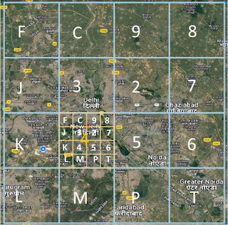
Level 1:
- • Level-1 labeling uses only digits 2-9 to identify regions on the mainland.
- • Codewords beginning with P, W, and X are reserved for future or special uses.
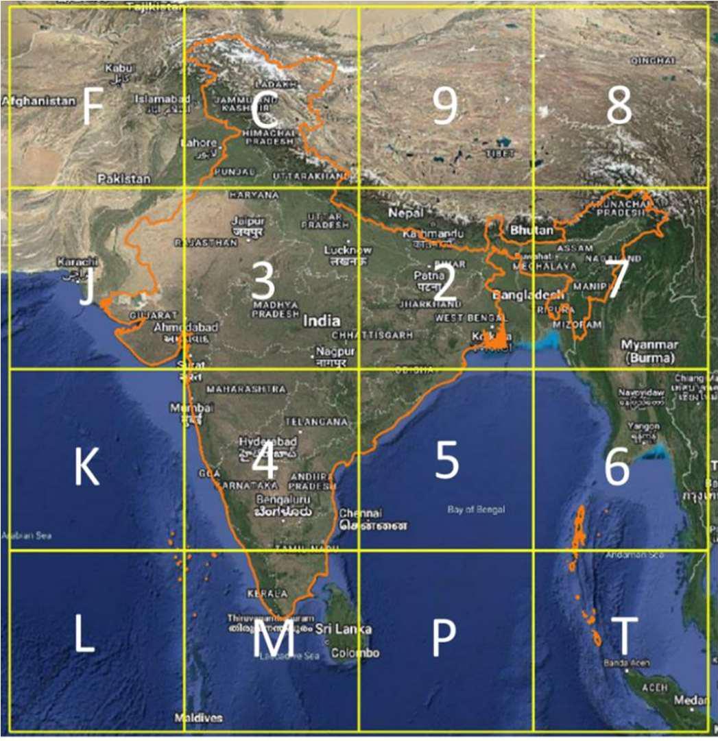
Level-1 Grid overlay showing regional divisions
Grid labeling pattern showing anticlockwise spiral direction for levels 2-10
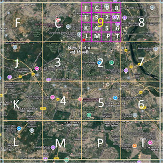
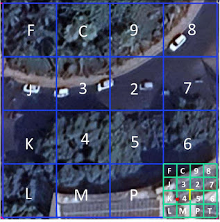
Level 2:
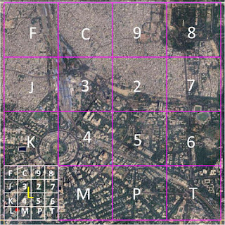
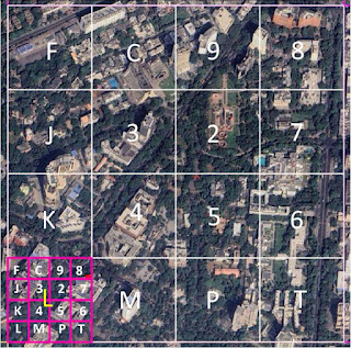
- • Each Level-1 region is further divided into 16 Level-2 sub-regions, as illustrated in the figure below. These regions are hierarchically partitioned into sub-regions in an identical manner.
- • For Levels 2 to 10, the same grid is used for labeling, and the labeling is performed hierarchically.
- • Symbols are assigned in an anticlockwise, outward-spiraling fashion. Note that this labeling grid differs from the one used for Level-1. The grid used for Levels 2-10 provides a sense of directionality and adjacency: cells labeled with consecutive symbols (e.g., 6 and 7) are geographical neighbors.
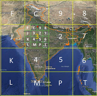
Level-2 Grid overlay showing regional sub-divisions
Note: The Level-1 grid, on the other hand, is designed to use numerals 2-9 specifically for mainland India. Furthermore, using two different grids—one for Level-1 and another for Levels 2-9—prevents the inadvertent labeling of locations outside India with the reserved symbols P, W, and X at Level-1.
The geographical coordinates of Dak Bhawan (28.622788°N, 77.213033°E) demonstrate the selection of DIGIPIN symbols at each level. The DIGIPIN of Dak Bhawan is:
39J-49L-L8T4
| Level | Symbol | Description |
|---|---|---|
| Level 1 | 3 | Primary region covering North India |
| Level 2 | 9 | Sub-region within Level 1 |
| Level 3 | J | Further subdivision |
| Level 4 | 4 | Continuing hierarchical division |
| Level 5 | 9 | More precise location |
| Level 6 | L | Neighborhood level precision |
| Level 7 | L | Block level precision |
| Level 8 | 8 | Building level precision |
| Level 9 | T | Room level precision |
| Level 10 | 4 | 4m x 4m grid precision |

Level - 1
Levels 2 subdivision

Levels 3 subdivision
Level 4 subdivision
Level 5 subdivision
Level - 6 subdivision
Level - 7 subdivision
Level - 8 subdivision
Level - 9 subdivision
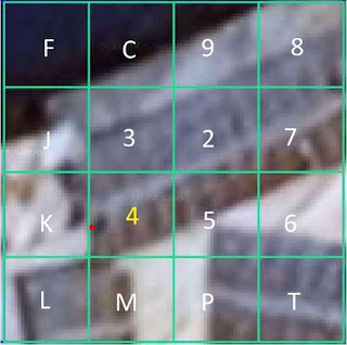
Level 10 - Final 4m x 4m precision
• This documentation has been carefully prepared based on publicly available resources and information officially released by the Government of India regarding the DigiPin initiative. All rights and ownership of the Images, Documents and Code belongs to Government of India; used for fair and educational purpose.
• The aim is to simplify the understanding of what DigiPin is, why it has been introduced, how it works at a technical and practical level, and what impact it can have on delivery services, governance, and citizen convenience.
• All technical details, diagrams, and workflows referenced in this documentation are either sourced directly from the official releases or derived from public presentations, press releases, and pilot project data shared by institutions involved (such as India Post and IIT Hyderabad).
• For more accurate and detailed information, or to stay updated with future developments and official releases, please refer to the links below:
Available Resources:
Technical Document
Download the complete technical document detailing the code and architecture of DIGIPIN grid
Official Gov Web App
Access the official beta version to capture DIGIPIN values
Programming Code
Download the programming code of the DIGIPIN grid logic
Submit Feedback
Send your comments and suggestions to help improve DIGIPIN